AcreVision℠
Find land, recent sales & understand land value, productivity, soil quality and cropping history with one simple tool.
Transparent Decision Making for Farmers
FBN® Finance is committed to bringing new technology to farmers that gives you the power to make informed decisions for the future of your ag operation.
AcreVision℠ was built to empower producers with a transparent look at key land information when deciding if a parcel of farmland would be a good fit for their operation.
The tool is currently available exclusively to FBN members.
How to Use AcreVision℠
AcreVision℠ supports farmers by:
Providing free, objective research to empower farmers to evaluate land
Helping compare comprehensive insights versus county level information
Enabling them to assess the land’s potential to support their ag operation
To use AcreVision℠, follow the steps below:
Create an FBN Account: If you're not already a member, click here to create a free account today.
Locate Your Parcels: Use the search box to find specific parcels based upon state, zip or street. Get more information by selecting up to 4 parcels.
View Details: Once you've selected the parcels you're interested in researching, click “View Details” to learn more about the soil, terrain, water, crop history, and other insights.

What to Expect in an AcreVision℠ Report
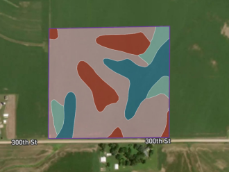
Soil Productivity
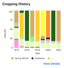
Cropping History
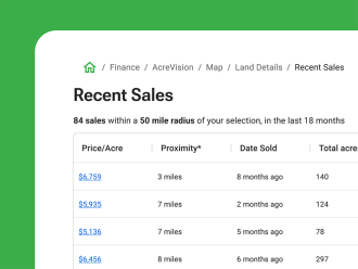
Recent Sales
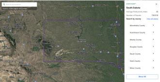
Advanced Filters
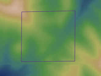
Terrain
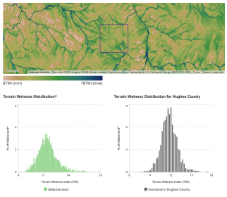
Terrain Wetness
Your Free Tool for Land Valuation
With FBN Estimate, farmers can review price per acre, total land value and an estimated price range after considering comparable sales in the selected farmland within a 50 mile radius.
The feature is now available in Illinois, Iowa, Indiana, Minnesota, Ohio, and Nebraska; more states will be added soon.
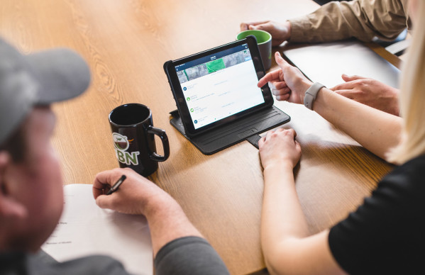
Pre-Qualify for an FBN Land Loan
Whether AcreVision has already given you insight into a parcel of land that you’re interested in purchasing or you are just beginning your land search, you can pre-qualify for a land loan through FBN Finance.
Just fill out the short pre-qualification form to see the loan amount you could qualify for up to $3 million. Pre-qualifying equips you with:
Peace of mind during a land search by knowing your budget parameters
Confidence going forward with your loan application
A competitive advantage in being able to make quick decisions about your land loan and future purchase
Pre-qualification information is valid for up to six months, and applying will not affect your credit score.
Our Latest FBN Financial Insights
Rent vs. Buy Farm Land: Which Is Right for You?
Fixed Rate vs. Variable Rates: Which is Better?

How Does the FBN® Finance Appraisal Process Work?
What Documentation Do I Need When Applying for an FBN® Finance Land Loan?

Webinar: Inflation, Interest Rates & What to Focus On

Will Farmland Values Continue to Climb into 2023?

How to Buy Land as a Beginning Farmer
The Impact of Rising Inflation & Interest Rates
Regenerative Practices Rebate Program
FAQs
What is the goal of AcreVision℠?
Land is one of the most important assets to a farming operation. This land evaluation tool provides everything you need to know about farm land parcels and local market trends in order to make the best decision around buying, selling, and financing land.
Does the tool list land for sale?
Our surveys of farmers tell us that most farm land transactions happen privately, without a public listing. In this tool, you can find detailed information for nearly every farm parcel in the United States, regardless of listing status. Currently we do not publish land listings.
When can I get access?
You can access this tool when you sign up as an FBN member!
Why can I only download a limited number of parcels per report?
FBN created this tool to make it easy for all farmers to access trustworthy farm land insights. We limit the number of parcels to aid in our mission of providing this data for farmers and not other audience sets.
How many reports or parcels can I access?
FBN members can view 3 reports (with a maximum of 4 parcels per report) every week. The week starts from Monday and ends on Sunday.
Can I see all the research and insights in the U.S.?
We currently have coverage in the lower 48 states.
Where does the data come from and how often is it updated?
This tool has a database of over 15.5 million agricultural parcels. We gather from a wide range of public data sources including local, state and federal government agencies, universities and private entities. We review the data to make sure that only the most relevant data is included
Parcels
Boundaries shown in the tool refer to tax parcel boundaries. They are sourced from county assessor records. For each parcel, we provide the boundary and the parcel identification (parcel ID), also commonly known as Assessor Parcel Number (APN) or property identification number (PIN). Parcels records are usually updated on an annual or semi-annual basis. How often parcel boundaries are updated will vary by county.
Land Use & Cropping History
This tool shows historical land use and cropping patterns derived from the Cropland Data Layer (CDL) published by United States Department of Agriculture National Agricultural Statistics Service (USDA-NASS). The CDL is a crop-specific land cover data layer created annually using moderate resolution satellite imagery. Land use and cropping history data are updated annually on AcreVision℠ in the first quarter of each calendar year when the USDA makes this data available.
Soil
We obtain soil information from the United States Department of Agriculture- Natural Resources Conservation Service (USDA-NRCS) and National Cooperative Soil Survey Geographic Database (SSURGO).
We show nation-wide productivity indices from SSURGO and state-specific soil productivity indices if those are available:
In Illinois we use the Illinois Soil Productivity Index (ILPI) for optimal management. Read more about ILPI and how it relates to yield and land values. Soil types with ILPI ranging from 133-147 are in Class A, from 117-132 are in Class B, and from 100-116 are in Class C.
In Iowa, soil productivity is measured by the Iowa C Suitability Rating (CSR2) which ranges from 0 to 100.
In all other states, soil productivity indices are determined by the overall National Commodity Crop Productivity Index (NCCPI) developed by the USDA-NRCS.
Soil survey information in AcreVision℠ is updated when new releases are published by the USDA-NRCS, typically every 1-2 years.
Terrain
The report presents farmland slope, elevation and terrain wetness index (estimating the propensity for water accumulation) using data from the United States Geological Survey (USGS).
Comparison of farmland to its county only considers cropland and not other land types.
Recent Sales
We obtain sales information from county records wherever the counties or states are disclosure states.
Sales information is updated weekly.
Why doesn’t the data in my report match what I see on my farm?
This tool was created to serve farmers across the country with detailed parcel-level analytics.
In order to provide information about 600 million+ acres, we incorporate many datasets derived from satellite imagery. For example, the USDA Cropland Data Layer used satellite imagery to estimate annually which areas produce what type of crops. However, errors may occur leading, for example, to one area of a field being classified as not planted when it actually was.
We always recommend supporting your analysis and research with on-the-ground information.
I want to share feedback about this tool. How can I do so?
You can reach us at explore-finance@farmersbusinessnetwork.com and share your feedback!
How much does it cost to use?
This tool is free to use. By being an FBN member, you will receive bonus data points such as an extended cropping history, plantable acres and comparisons between the farmland with the county.
Why is my report missing information for certain parcels?
We do our best to provide you with all the data and insights that we can for the parcels that you have selected. Even though we use a variety of sources, sometimes there are cases where data is not available for each parcel.
What are the terms of use?
By accessing this report and the information therein, you agree that the information in this report is provided for your individual informational use only, and may not be disclosed, reproduced, summarized, distributed, excerpted, or used for any reason other than for research purposes to aid in your potential purchase, sale, or rental of property. Any unauthorized use of this report or its information is prohibited. Information is reliable but not guaranteed, may be incomplete, and should be independently verified. Farmer’s Business Network, Inc. and its subsidiaries are not responsible for the accuracy of this information.
What is FBN Estimate and how is it derived?
FBN Estimate is FBN’s estimate of a farmland parcel’s market value. It leverages proprietary machine learning models that incorporate datasets on farmland transactions, land productivity, land use and more to inform the estimate.
How often is FBN Estimate updated?
FBN Estimate is updated at least on a weekly basis, or whenever there are factors that warrant a significant change in the Estimate. These factors can include new comparable sale transactions and updates to estimated land productivity.
FBN Estimate seems too high or too low. Why?
The amount of data, especially comparable sales, for farmland in your selected area affects the accuracy of FBN Estimate. We also obtain information from publicly available data sources, such as the United States Department of Agriculture National Agricultural Statistics Service (USDA-NASS) and United States Department of Agriculture - Natural Resources Conservation Service (USDA-NRCS). However, we do not factor in buildings, improvements or irrigation, which can also affect estimates.
Can I use FBN Estimate to get a loan?
FBN Estimate is provided for informational purposes only and should not to be construed as an appraisal or evaluation for any individual parcel, nor should they be considered a reliable indicator of the current or future valuation of the land, as various factors can significantly influence an individual parcel's value. Please discuss with your lender any questions on using FBN Estimate to obtain a loan.
Why is FBN Estimate only available for certain parcels?
FBN Estimate is currently available in six states (Iowa, Illinois, Indiana, Ohio, Minnesota and Nebraska). Compared to other states, we have more complete information in these states that inform our data-driven models to arrive at an estimate. Watch this space as we continue to expand our coverage across the country!
Is FBN Estimate an appraisal?
FBN Estimate is not an appraisal and cannot be used in place of an appraisal. It is a computer-generated estimate of the value of a parcel of farmland today given the available data.
We encourage users to supplement FBN Estimate with other research, including getting a professional appraisal of the farmland as needed.